臺灣省全圖
The COMPLETE MAP of TAI-WAN PROVINCE
オーストラリア国立図書館所蔵
Creator:CHINA MAP SERVICE SURVEY DEPT. CCSF
中華民国 連合勤務総司令部測量所
Title:T`ai-wan province / prepared by China Map Service Survey Dept. CCSF
以下は、オーストラリア国立図書館の説明文
Created/Published:[Beijing]: China Map Service, Survey Dept. CCSF, 1956
Map of Taiwan, showing province and district boundaries, transportation, ground and water features, built-up areas and other populated places. Relief is shown by contours, hachures and spot heights. Depth shown by hypsometric and bathymetric tints.
なお、同じと思われる地図が内閣官房領土・主権対策企画調整室にも紹介されている。
http://www.shindo.gr.jp/cms/wp-content/uploads/2016/10/20161027_ryoudo_04_naikakukanbou.pdf
こちらの説明によると
[台湾省全図][1956年(昭和31年)9月]US Army Map Service [連合勤務総司令部測量所(中華民国)[日本、South Korea、台湾島の地図](沖縄県公文書館所蔵(エドワード・フライマスコレクション))
とある。
オーストラリア国立図書館側には「中華民国の作成した台湾省図をAMS(旧米国陸軍地図局)が出版したもの」との説明はない。なお、CCSFの意味は調べたが不明。
本ブログが引用のオーストラリア国立図書館所蔵の地図のウェブ画像所在:
T`ai-wan province [cartographic material]

左下部分:次の通りの文字が確認できる
「CHINA MAP SERVICE SURVEY DEPT. CCSF SEPT, 1956」
「中華民國四十五年九月聯合勤務總司令部測量處發行」

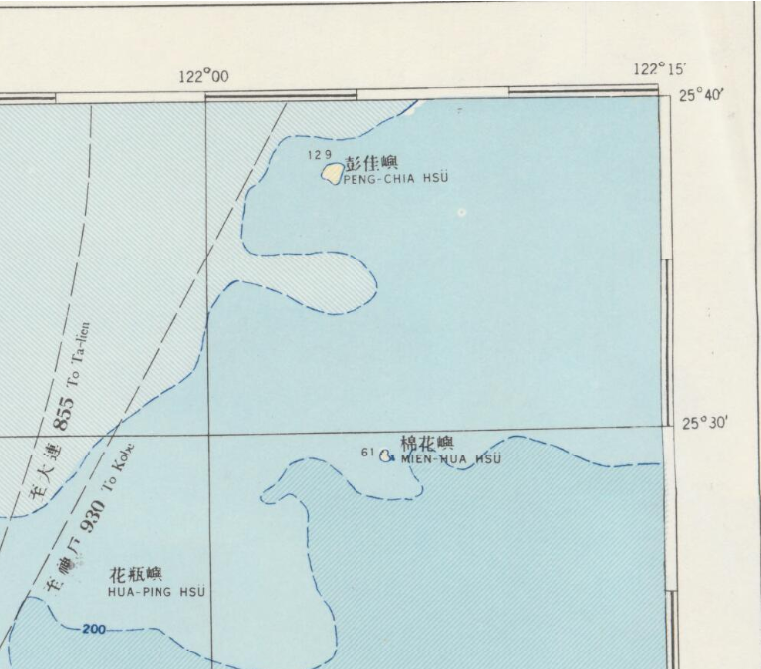
北東部分拡大

拡大

参考 三仙台付近拡大

所見:
中華民国の作成になる地図に「臺灣省全圖」と表記されているにも拘らず、尖閣諸島は描かれていない。
昭和31(1956)年当時の中華民国政府の認識を示している。